North Shore - Bell's Trailhead to Cougar Overlook Figure 8

Flood Debris
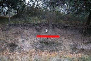
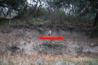
This chair was left behind from the July 4th flood. I am almost six foot tall and the red line is about where the top of my head would be as I stood on the trail on the opposite bank.
User: MikeHikes - 12/17/2025

Location: San Angelo State Park

Rating: 4stars
Difficulty: halfstar  Solitude: 5stars
Miles Hiked: 7.40 Miles  Elapsed Time: 3 hours, 45 minutes

Comments:

Leg 1 -  Bell's Trailhead > Shady Trail > park service road (SW) > Rocky Creek Trail > park service road (S) > South Slick Rock > River Bend Campground > Upper Ghost Camp Trail > Trailhead to Trailhead (S) > Cougar Overlook       3.5 miles

Leg 2 -  Cougar Overlook > Javelina Trail > River Bend (W then N) > Badlands > Trailhead to Trailhead (N) > Bell's Trailhead     3.9 miles

Temp started at 50, ended at 56.  Overcast for the 1st 2/3 of the hike then partly sunny with clouds.  0-5mph Westerly breeze, light humidity.

Easy hike along recently opened trails with the Lower Ghost Camp Trail still CLOSED.  Shady Trail and the North Scenic Loop have reopened.  The July 4th flood was pretty severe and left a lot of debris scattered about (photo attached).

Due to the temperature and the overcast skies, there was almost no bird activity and only a few deer were out.  The only good news is the river still has water in it.  For this park, that is very welcome news!

NOTES - 

Info kiosk and a bicycle repair station are available at Bell's Trailhead.  Water and shade available at nearby campsites.

Water, shade, info kiosk and dry toilets available at River Bend Campground.

Shade, info kiosk and a bicycle repair station available at Cougar Overlook.


Log Photos
Flood Debris
Area around San Angelo State Park