South Shore - Playground parking area to Armadillo Ridge Figure 8

What'cha Doing?
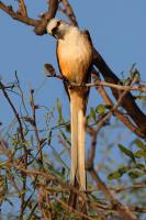
Right at the Chaparral trailhead high in a large mesquite tree, this Scissortail was illuminated by the morning Sun. As I stood there and snapped a few photos, he gave me this inquisitive look.
User: MikeHikes - 6/12/2024

Location: San Angelo State Park

Rating: 4stars
Difficulty: 1star  Solitude: 4stars
Miles Hiked: 10.70 Miles  Elapsed Time: 5 hours, 45 minutes

Comments:

Leg 1 - Playground parking area > Chaparral > Red Dam Loop > Chaparral > Winding Snake > Burkett Park     3.2 miles

Leg 2 - Burkett Park > WS to LL Connector > Roller Coaster > West Potts Creek > Potts Creek > Burkett Trail > Burkett Park    3.8 miles

Leg 3 - Burkett Park > WS to LL Connector > Lanky Lackey > Nature Trail > Tasajilla Flats > Playground parking area   3.7 miles

Temp started at 70, ended at 89.  Sunny with a few clouds. Fairly constant 0-5mph breeze from the SE.

Slow easy hike along dew dampened then dry trails that are easy to see and traverse.  Lots of birds out today especially Mockingbirds and quail.  I saw two Horned Toads at different locations which is unusual but very welcome to see.  Only animals I saw were deer and a couple of cottontails.  Overall, it was a very nice hike along familiar trails that I thoroughly enjoyed!

NOTES -

Water, shade, info kiosk, toilets and a bicycle repair station are available at Playground Parking Area.

Water, shade, info kiosk and dry toilets available at Burkett Park.


Log Photos
What'cha Doing?
Area around San Angelo State Park