Out Playground > Tasajillo Trail > Nature Loop > Lanky Lackey > Rollercoaster Trail > West Potts Creek > Armadillo Ridge Trail > Junction of Armadillo and (East) Potts Creek Trail 5.1 miles
Return (East) Potts Creek Trail > Burkett Trail > Winding Snake > Chaparral Trail 3.3 miles
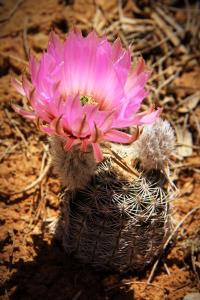
This loop takes you West then North from the South Shore playground parking lot along the western edge of the park to Armadillo Ridge before going east then south back to the playground area - in effect, this route forms a large rectangle. This hike encompasses most of the South Shore's trails and goes just a little further into what I call the middle section of the park. All the trails are easy to follow and are for the most part, composed of small rock and dirt; some inclines but nothing severe. Mesquite trees are starting to leaf out and a few cactus are blooming notably the horse crippler and lace cactus. Nesting time is beginning as well so many song birds can be heard and seen establishing their territory.
Starting at Tasajillo Flats, you head West and then North as the trail takes you through mesquite groves, open spaces and lots of native grasses. The trail ends at the connection with Nature Loop trail and there, you will turn left (North). A short distance away a junction appears and you turn right (East) onto the bigger portion of Nature Loop.
Nature Loop Trail ends nears the entrance to Isabel Harte Multiuse Area; Lanky Lackey starts directly across the road. Take Lanky Lackey to the end and you connect to Rollercoaster Trail - aptly named but not extremely difficult to hike. Rollercoaster is a long trail and at one point, the trail is on a dirt road for a short distance before the trail re-emerges on the right. At trail's end, West Potts Creek signpost is visible; take it and follow to the end which connects to Armadillo (Ridge) Trail.
Follow Armadillo Ridge trail East until it connect to (East) Potts Creek Trail - there is a signpost at the junction. Take East Potts Creek which goes South, and you will come to the signpost for Burkett Trail. Follow the trail along the bottom edge of the finger of land where Pulliam Point is located and continue in a southerly direction to Burkett Park where dry toilets, water, an info kiosk and shade are.
Winding Snake Trail signpost can be easily seen and you will follow the trail South. The trail runs for a little over a mile and ends at a gravel road at the Isabel Harte area. Follow the gravel road to the end and you will see the signpost for Chaparral Trail which drifts South and West. Take the trail across the ravine and up the next side. Continue on this trail and you will eventually cross a paved road.
After walking for awhile, the trail will look like it terminates at the end of an embankment. Directly ahead is the signpost for Talley Valley which you will NOT take; instead, you will turn left on the gravel road and walk for about 30 meters and look to the right for the remainder of Chaparral Trail. Follow to the end and you are back at the playground parking area.
NOTES
(1) Info kiosk, water and toilets are available at the starting point, Playground parking area, and a little past the midway point, Burkett Park.
(2) Trail names - Not all the trail names match what is on Google Earth and the trail map. Some signposts have various spellings - for example "TasajillA Flats" and "TasajillO Flats" for the same trail, the eastern portion of Potts Creek Trail is labeled "Potts Creek" whereas the western portion is labeled "West Potts Creek" AND in this case, Google maps has Armadillo Ridge Trail connecting to Burkett Trail and Rollercoaster Trail omitting any mention of east or west Potts Creek Trail. I have tried to be as consistent as possible in the names in my log entries. Please purchase a park map for $3 at the South Shore gatehouse.
(3) Time of hike - Don't assume the time listed is an indication of the terrain or trail's difficulty in traversing it; when I hike, I'm in no hurry!! I take photographs, pick up any trash I find along the trail, watch the birds and enjoy being with nature.