Northeast Metropolitan Park

Trail
2.00 Miles
250 Feet
N/A
3stars (3.43)8
1star (1.00)
1point5stars (1.86)
N/A
Yes
Yes
No
Pflugerville
Travis
More Info

Getting there: From I-35, head east on FM 1825 and continue through Pflugerville. The road turns into Pecan Road and narrows. The park entrance is on the right in about 5.5 miles.

The Hike: Northeast Metro Park is one of three relatively new Travis County parks to dot the county's east side, the other two being East Metro Park (Manor) and Southeast Metro Park (Del Valle). The trail surface here is all concrete and almost completely flat. This detracts from a pure hiking experience, but those looking for a nice stroll or a mud-free walk after a rain, it might fit the bill quite nicely.

The trailhead is located at that waypoint "Trailhead". It's located just across street from the main parking area for the many soccer fields the park hosts. Please don't park next to the trailhead itself. There's no reason to contribute to making the area look like a lunar landscape. There's plenty of parking across the street, and you are coming here to walk/hike, right?

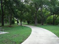
Much of the trail is in the shade. Several benches along its path provide a convenient spot for a picnic.
The trail consists of two sections, with the trailhead serving as the junction point in the middle. The segment heading to the south is by far the more interesting section of trail and unless you have an overriding desire to hike every foot of the trail I'd suggest you limit your visit to this half.

The concrete path parallels Gilleland Creek, sometimes passing quite close to its banks. Because it's passing through creek bottomland there is ample tree coverage only rarely is the trail exposed to the Sun. There are numerous picnic benches along the trail, some in the nice, shady spots created by the foliage.

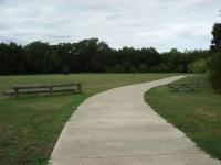
The loop at the end of the southern half of the trail has yet more picnic benches and an open field.
Despite being close to a large number of popular soccer fields it's not too difficult to find some solitude on the trail. The tree and brush cover provide some shielding from the noise eventually and since the trails are not the main draw to the park, it's quite possible to have the trail to yourself. On my visit I encountered only one cyclist and a pair of park workers emptying trash cans.

The southern half of the trail ends in a large loop that closes in on itself and thus presenting the opportunity to double back to the trailhead. More picnic benches can be found here to pass the time away from the crowds at the soccer fields.

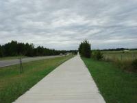
The northern half of the trail is not so nice. Really just a sidewalk here.
The northern half of the trail system here is really not much more than a sidewalk on the road that goes into the park. In proceeds north past a couple of baseball fields and then forms a perfectly straight line until it reaches the park entrance on Pecan Road. Though some vegetation has been planted between the road and trial, it does little to shield the walker from the noise and commotion of people coming into and leaving the park.

It's a little confusing why the northern trail leading into the park was not placed on the other side of the road. Since the property line would not have been right up against the road and sidewalk it would have been possible to separate the walkers from the cars and make that segment of the trail more pleasant. Perhaps they have future plans for the parkland there.

Travis County residents in and near Pflugerville now have a good sized park for outdoor recreation. If you're looking for the best possible walking/hiking experience just double up your mileage on the southern half of the trail system here and avoid the northern sidewalk.

Log Entries
Lots of Shade!
By plectrudis on 2/1/2021
Rating: 4stars Difficulty: 1star Solitude: 2point5stars
Distance: 2.00 Miles Duration: N/A

This trail isn't super-long, and it's paved, but if you start at the baseball diamonds and head back toward the big loop, most the your walk will be very well shaded, plus it runs along a nice little creek, though it's not always terrible visible through the undergrowth.  There's an especially pleasant pecan grove sort of area, and some exercise equipment dotted along the path.  You'll definitely see other people, but they haven't ever been too numerous or bothersome.  There's also a small weir or dam sort of thing--not _very_ scenic, but it makes a lovely sound.  The park as a whole has a ton of recreational facilities, for those who want to do things other than walk.

By cwlatapie on 2/24/2013
Rating: 3point5stars Difficulty: halfstar Solitude: 3stars
Distance: 5.00 Miles Duration: 2 hours
Great place for sports picknicking or hiking
By cwlatapie on 5/20/2012
Rating: 4point5stars Difficulty: 1star Solitude: 2stars
Distance: 15.00 Miles Duration: 6 hours

Very clean sports park I often spend all day hiking, biking, throwing the frisbee or just hanging out with friends here.

Nice park, but not a great hike
By sjs on 7/11/2010
Rating: 2point5stars Difficulty: 1star Solitude: 1star
Distance: 1.25 Miles Duration: N/A

Nice park, but not really what I'm looking for in a "hike," given that it's so public and paved.  And beware -- I sat under a tree near the soccer fields to draw in my sketchbook, and I got a ton of chigger bites!

Okay loop
By texaskdog on 3/29/2010
Rating: 3stars Difficulty: 1star Solitude: 1star
Distance: 3.00 Miles Duration: 45 minutes

Lots of trees and a creek.  I'd give it 2.5.  Nice trail for bikes.

The pond looks better after a good rain.
By JustWantToPaddle on 6/2/2007
Rating: 4stars Difficulty: 1star Solitude: 2stars
Distance: 4.00 Miles Duration: N/A
Does anyone know what control is on the Cedar Park WasteWater Treatment Facility as far as the amount of effluent they put into Brushy Creek upstream of this park?
Nice hike and bike path
By Austin Explorer on 9/24/2006
Rating: 2point5stars Difficulty: 1point5stars Solitude: 1point5stars
Distance: 4.40 Miles Duration: N/A
Concrete surface throughout and mostly flat. South of the trailhead the path is shaded and set back from the road and parking spaces. The northern half parallels the road (which can get busy with soccer tournaments) and should probably be avoided unless you just want to add some more distance. There are some nice picnic spots along the southern half of the trail and some measure of solitude there as only one other person was on the trail during my walk.
Recommended Item
Recommended Item 60 Hikes Within 60 Miles: San Antonio and Austin: Including the Hill Country
Charlie Llewellin, Johnny Molloy
List Price: $18.95 Your price: $15.91 Buy Now
It's Time to Take a Hike in San Antonio!

The San Antonio and Austin areas are steeped in history -- San Antonio's Alamo stands as a symbol of Texas' fierce independence, while Austin is recognized as the cradle of Texas statehood. This area is also known for some of the most impressive hiking in the Lone Star State. 60 Hikes Within 60 Miles: San Antonio and Austin, by veteran authors Charlie Llewellin and Johnny Molloy, guides readers to the best trails found in the Texas Hill Country, all within easy reach of these two cities. The guide takes you to secluded, low traffic areas as well as those that are more popular and heavily used. The former LBJ Ranch, the Guadalupe River, the Highland Lakes Chain, and the Lost Pines area are just some of the spectacular places covered.

With this new edition in the best-selling 60 Hikes Within 60 Miles series, all these visually stunning and ruggedly charming routes are at the traveler's fingertips. This handy guide helps San Antonio and Austin natives get back into nature, with many options right in town. Extensive at-a-glance information makes it easy to choose the perfect hike based on length, difficulty, scenery, or on a specific factor such as hikes good for families, runners, or birding. Each trail profile includes maps, directions, driving times, nearby attractions, and other pertinent details.