Allen Park

Trail
0.70 Mile
150 Feet
Free
3stars (3.21)8
1point5stars (1.69)
2point5stars (2.63)
N/A
Yes
Yes
No
Austin
Travis
More Info

Getting there: From MoPac take the Koenig Lane/FM 2222 exit and head west. Turn right on Balcones Drive and heard north. Turn left onto Hart Lane and then turn left again almost immediately onto Westside Drive. Look for the small parking area on the left at the base of a small rock face.

Heading in a counter clockwise manner, the trail starts to the south along the ridge that rises above the parking area.
The Hike: Allen Park is a small neighborhood-type park that is part of the Travis County system of parks. Despite its small size, it features an enjoyable loop of easy hiking and some great facilities for picnics. From the trailhead at the parking area along Balcones, the trail is crushed gravel and twists and turns up the short rock bluff overlooking the parking area.

There are a few trail segments consisting of steps where steepness of the terrain required it.
A set of stairs leads off to the left soon after starting. Ignore them for now, I'll be coming down them on the way back. Instead continue to the right along the trail as it hugs the edge of the bluff heading south. Once to the edge of the park property the trail turns to the east and slightly uphill. The trail will pass near the backyard fence of a couple of houses, one of which serves as territory for a couple of dogs none too pleased with the visit. But they are held in check by a wood privacy fence and the trail will soon turn away from the houses and back into the heart of the park.

On our trip the turn away from the houses coincided with a small meadow opening which sported lots of wildflowers. The primary showman in late April was the Indian Blanket, though there were plenty of other varieties as well. The path leads in a straight line to the northern edge of the park. Farther up, a turn to the left will lead to a Pavilion that I'll encounter later.
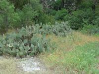
The interior of the park features small meadows with plenty of cacti and wildflowers.  Quite a surprise.
The interior of the park features small meadows with plenty of cacti and wildflowers. Quite a surprise.
When the trail runs into the northern boundary of the park it turns to the right and begins to descend towards Balcones. There is plenty of loose rock on this section of the hike so be careful. To the left lies the property of a church.

At the bottom of the descent, the trail turns to the right and into an opening. It's easy to see that this area has been used for a dumping ground and/or a construction staging area in the past. There's some trash, though thankfully not very much, and lots of what appears to be bits of asphalt on the ground. Although not the most picturesque portion of the hike, it does have it's high points. Though not as numerous, the wildflowers down here included some beautifully large examples of Indian Blanket and Coreopsis.

The ample tree and brush cover at the center of the park makes one easily forget all of the roads and homes nearby.
From this point I retraced my steps back up the hill to the church property line. There I proceeded forward down the slope on the other side of the ridge. A side trail to the right leads to the church parking lot.

The trail veers to the left and into the main picnic area, which includes a large pavilion that can provide shelter from a brief shower. There's also a playground-type area here with a few things for the kids climb on and under.

To finish up the hike follow the trail to the opposite side of the playground area and descend the steps that I passed early on in the hike. Then retrace your steps to the trailhead. I spent 37 minutes strolling through the .7 miles of Allen Park. Prior to starting the hike I was not expecting very much, just a chance to walk a little. The park provided more enjoyment than normally one would consider from a 10 acre neighborhood park.

Photos
Old large stone block
There are several large stone blocks such as this one off of the trails at the park. I'd like to know the story behind them. (Photo by heatharcadia)
Austin skyline as seen from the back upper trail
The trail along the ridge at the back of the park has some pretty okay views of the city, including the downtown skyline. (Photo by heatharcadia)
Allen Park
Allen Park Mini Wilderness Trail (Photo by Ginger)
Log Entries
Great place for my "I need a short hike!" moods
By heatharcadia on 1/24/2016
Rating: 3stars Difficulty: halfstar Solitude: 2point5stars
Distance: 1.91 Miles Duration: 1 hour, 9 minutes

Sometimes I need a place near home to go and just wander in nature to clear my mind. This is that place. The trails are not challenging at all, so it is a relaxing hike. I hardly ever see others here, even though there are several picnic tables and grills, which would make it a good spot for picnicking. 

I am not sure how many miles of trail there actually are here (it's not much, I know that) because I always end up wandering in circles when I'm here. There are some pretty nice views of the Austin skyline from the upper back trail, and if you're into Geocaching be sure to grab GCBC90 "It's Balcones Fault... Too" while you are here.

One downside is that it is very close to MoPac, so there is no escaping the traffic sounds.

By austinali27 on 10/21/2010
Rating: 3stars Difficulty: 1star Solitude: 2stars
Distance: 0.70 Mile Duration: N/A

Trail is close to my work so I went over today on my lunch break and got a nice easy walk/hike in.  It's a cute hike with lots of cacti and wildlife.  It was amazing to find this place in the middle of a neighborhood.  Lots of picnic tables.  Maybe I'll bring my lunch there someday! 

Nice for a neighborhood park
By texaskdog on 7/31/2010
Rating: 2stars Difficulty: 2stars Solitude: 2stars
Distance: 1.00 Mile Duration: 15 minutes

Lots of wilderness for a neighborhood park, though you can hear Mopac throughout. 

Mini wilderness hike
By Ginger on 11/22/2009
Rating: 3stars Difficulty: 2stars Solitude: 3stars
Distance: 0.70 Mile Duration: N/A

Typical Texas trail with live oaks, limestone and cacti, but a sweet little miniature version.  Went on a damp Sunday morning and it was quiet and empty.  The edges of the park are near houses/ church, but nobody was out in their yards. Plenty of picnic spots if you're so inclined.  The ups and downs are a little trickie, but otherwise it's an easy hike.

By jjuday on 1/5/2008
Rating: 4stars Difficulty: 2stars Solitude: 3stars
Distance: 1.00 Mile Duration: 45 minutes
Fun Hike with a Toddler
By jjuday on 1/7/2007
Rating: 5stars Difficulty: 2stars Solitude: 3stars
Distance: 0.70 Mile Duration: 30 minutes
Nice place to take a toddler for lunch. Lots of picnic tables. Trail is short for an adult but a nice length for a little one.
Short quiet hilly hike
By figment on 7/12/2003
Rating: N/A Difficulty: 3stars Solitude: 2point5stars
Distance: 0.70 Mile Duration: N/A
This is a nice hike if you live in the area or if you have a dog. It's a little hilly. You do feel a little intrusive though, because the trail goes right by the backyard of some homes - including one with a pool. There are some nice picnic tables with a view of the hills here as well
Sometimes small parks surprise you
By Austin Explorer on 4/27/2002
Rating: 2point5stars Difficulty: 1star Solitude: 3stars
Distance: 0.70 Mile Duration: N/A
I thought this park would provide a quarter mile walk with a few trees and little more. Instead it provided some great stands of cacti and flowers to go along with a trail that, although short, provides a bit more of a workout than a typical hike and bike trail. I'll need to revisit the park at some point since I misplaced my GPS track file, so for now there's no trail map.
Recommended Item
Recommended Item 60 Hikes Within 60 Miles: San Antonio and Austin: Including the Hill Country
Charlie Llewellin, Johnny Molloy
List Price: $18.95 Your price: $12.59 Buy Now
It's Time to Take a Hike in San Antonio!

The San Antonio and Austin areas are steeped in history -- San Antonio's Alamo stands as a symbol of Texas' fierce independence, while Austin is recognized as the cradle of Texas statehood. This area is also known for some of the most impressive hiking in the Lone Star State. 60 Hikes Within 60 Miles: San Antonio and Austin, by veteran authors Charlie Llewellin and Johnny Molloy, guides readers to the best trails found in the Texas Hill Country, all within easy reach of these two cities. The guide takes you to secluded, low traffic areas as well as those that are more popular and heavily used. The former LBJ Ranch, the Guadalupe River, the Highland Lakes Chain, and the Lost Pines area are just some of the spectacular places covered.

With this new edition in the best-selling 60 Hikes Within 60 Miles series, all these visually stunning and ruggedly charming routes are at the traveler's fingertips. This handy guide helps San Antonio and Austin natives get back into nature, with many options right in town. Extensive at-a-glance information makes it easy to choose the perfect hike based on length, difficulty, scenery, or on a specific factor such as hikes good for families, runners, or birding. Each trail profile includes maps, directions, driving times, nearby attractions, and other pertinent details.