Between Mar 1-Jul 31, you don't need a permit here. But rules are technically 3 per group max, no dogs, no bikes.
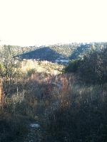
I started from just off of 360 South, first right after Spicewood Springs. The map provided was so undetailed, I had to backtrack several times. The most recognizable trail actually leads you around to the Bull Creek Greenbelt. If you want to go on the trails heading North towards St. Edward's, go behind the signage to the right, along the chain link fence. The path is sort of hidden.
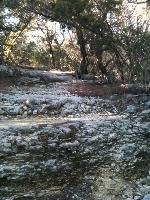
The thing that helped me the most was my smartphone GPS. I hadn't even planned on using it, but that was how I knew I was completely off the trail. (Well, that, and I ran into the Bull Creek waterfall.) Also, I bookmarked a topographical Google Map, which helped me find the path with the most elevation gain.
Even looking for the most elevation gain, I only got from 600 ft to 800 ft, only a 200 ft climb to the water treatment facility! It was really nice, a peaceful, beautiful day, with the most elevation I have climbed so far in Austin anyway. I am fairly new, so if anyone knows any hikes nearby that climb to the top of a really high hill... let me know :)