Getting there: From Austin head south on Highway 183. Proceed through Luling and turn right onto Park Road 11 south of town. The park ranger station is two miles down the road on the edge of the town of Ottine.
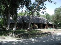
This impressive stone building was constructed by the Civilian Conservation Corps in the 1930's.
Palmetto State Park is one of those parks that serves as a reminder that there are exceptions to almost every rule. Bastrop and Buescher State Parks highlight the Lost Pines. The Lost Maples have their own park. Palmetto State Park showcases a wet, swampy terrain that seems out of place in Central Texas. However, this oasis is the remnant of what was once a much larger area that covered Texas long ago.
The most impressive building in the park is the impressive Refectory, built by the Civilian Conservation Corps in the 1930's when the park land was acquired. The stone structure seems to burst forth from the earth due to the way the CCC laid the foundation stones for the structure.
The park includes four short trails between .15 and 1 mile in length. The Palmettos lend an exotic air to the surrounding terrain. Although the area is swampy the ample tree cover provides some relief from the direct light of the Sun.
-small.jpg)
The trailhead signs and interpretive trail guide box at the start of the hike.
Like all trails at Palmetto, it's a short stroll through flat, muggy terrain. The swamp-like conditions could mean oppressive heat in the middle of summer, but on our visit during August the heavy tree cover over most of the trail help offset the high temperatures.
The trail begins at the waypoint "Trailhead" on the map. There is a sign along the side of the road and a wooden box in which interpretive trail guides that are used for both this hike and the nearby Palmetto Trail. The guide includes some excellent illustrations so we suggest that you pick one up.
-small.jpg)
Soon after starting the trail descends to the terrace above the river's banks.
The trail descends down a set of stairs towards the San Marcos River soon after the trailhead. From this point on the trail will follow along the banks of the river for almost a quarter mile. The banks of the river consist of loose dirt that is easily eroded away by the river, so there are few spots at which to get really close to the water.
The trail conditions were improving after the disastrous floods that plagued much of Texas a couple of months earlier. While the trails were cleared of debris, there was plenty of branches and brush piled up here and there along the trail as a reminder. The surface of the trail is often sandy, particularly along the river's banks.
-small.jpg)
The section of the trail along the river bank gets the most Sun and is the most sandy.
After covering a bit over .15 miles the trail comes to a Y, marked on the map by the waypoint "Y-Left". The guide did not indicate which way to go, so we choose left to complete the loop in a clockwise direction. It turns out that this is not the way you want to go if you wish to follow the interpretive guide in numerical order.
-small.jpg)
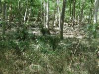
The heavy tree cover provides relief from the Sun away from the river.
As the trail turns to the south and prepares to return back to the trailhead the hiker is presented with the closest approach to the river. It's possible to get down to the level of the water, though the river is often murky in this section due to the nature of the river's banks. The soft soil is easily carved by the river, which can result in it changing direction in a geographically defined moment's notice. Elsewhere in the park lies an oxbow lake that was created when the river changed course and cut off the flow of water from a former path, which turns into a pond.
The trail turns away from the river and a change in vegetation becomes apparent quickly. There is more shade due to the thick tree cover and whereas the river banks seemed to have a wider variety of foliage there seems to be much greater concentrations of fewer species here such as Elms and Hackberries.
The trail makes it way back to the Y split earlier and then retraces its steps upstream and back to the trailhead. We recorded a trail distance of half a mile and completed the hike in 52 minutes, which included time spent reading the interpretive trail guide.
-small.jpg)
A view along the well shaded trail. Note the few Palmettos to the right.
Unlike the nearby River Trail and Palmetto Trail, the Hiking Trail does not provide an interpretive guide. That allows for one to concentrate on their hiking and letting their mind wander as they stroll through the forest.
The trail begins at the waypoint "Trailhead" on the map. Not long after starting, in fact too short a distance to include another waypoint on the map, lies an interesting little sight along the trail. We can't tell you exactly what it is since that would give away the answer to the
Geocache hidden in the park during our visit.
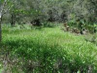
Now a perfect spot for these moisture loving plants, this natural bowl used to contain boiling mud.
After a couple of turns in the trail a sign to the left indicates the presence of a Mud Boil. Yet, what appears here instead looks at best to be a vegetation rich depression in the ground. This is one example of the changing landscape in the area. Not that long ago this area was wetter and more geothermally active. Artesian springs dotted the landscape and hot springs and other formations created mud boils like the one that used to be here. The activity stopped in the 1970's, probably due to the changes brought about by the wide spread drilling for both oil and water in the area.
These natural depressions in the terrain retain moisture even after the standing water evaporates away. It's terrain like this that the Palmettos love.
At about .2 miles into the hike the trail splits into a Y at the waypoint "Y-Left". We proceeded to the left to complete the loop of the trail in a clockwise manner. Either choice should suffice on this trail.
Much of the trail is well covered by trees, which are predominately Elms and Hackberries here. Though fewer in number here than on the Palmetto Trail, there are numerous Palmettos in this area of the park also.
The surface of the trail is dirt with a few sandy spots. Like the rest of the park, there is almost no elevation change, which makes for an easy hike.
Palmetto State Park displays a number of signs warning people about the presence of snakes. The only snake that we observed on our three hikes in the park was on the Hiking Trail. The snake was some distance away from us on the opposite side of a small temporary pond. Startled by our presence, the snake froze for a few minutes until it finally slithered off behind a tree. While being on the lookout for snakes is always a good idea, there's no reason to allow the fact that snakes find the park a great place to live spoil your visit.
The trail completes a loop, returns to the Y and then retraces a path back to the trailhead. We found the trail to be just shy of 1 mile and we completed the hike in 38 minutes. Without an interpretive trail guide we were able to complete the longest hike in the park as fast as, if not quicker, than the others.
-small.jpg)
The Palmetto Trail gets its name from the abundant Dwarf Palmettos that line the trail.
This short hike is the signature hike of the park. It includes the largest concentration of Palmettos that you're likely to see in this part of the country.
The Palmetto Trail is one of two trails in the park that features an interpretive trail guide that describes many of the plants that can be found here. The guide is available in a box at the trail end, which you will pass on your way from the parking area at the Refectory.
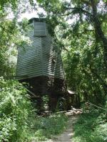
This tower is part of the man-made system that keeps the area moist enough to maintain its Palmetto population.
A short distance after the trailhead the path comes upon a water tower partially shrouded by the forest. What's a water tower doing here? Human activity in the area has drastically changed the environment. Oil and water pumping in the area has altered the flow of underground water that the Palmetto groves relied on for moisture in the past.
In order to save the Palmettos that remained here, the Civilian Conservation Corps built an artesian well to pump water from deep underground and bring it to the surface. The water tower stores some of the water before it is released at the surface.
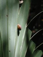
Palmetto leaves are a favorite spot for several land snail species. Some individual plants hosted scores of snails.
The trail is very flat and easy to navigate. Very often the trail is framed by thick stands of Dwarf Palmettos. Although Palmettos can grow to as high as 18 feet tall, that does not happen much within the park boundaries. Instead, those within the park have the tops of their foliage stand between three and four feet tall. During our visit in August the Palmettos had already passed the flowering stage and were bearing small spheres of fruit on stalky stems.
The Palmetto leaves are a favorite spot for several land snail species. One of them,
Stenotrema leai cheatumi, was first discovered to science in this very area. In addition to the Palmettos, the snails seem to prefer the bark of the hackberries over those of other trees.
-small.jpg)
The trail is quite easy to hike. This small bridge even makes getting over the small gully easy.
The Dwarf Palmetto is more common along the Gulf Coast from Louisiana to Florida. The population of Palmettos here are somewhat out of their typical range. In this regard they share some characteristics with the Lost Pines or Lost Maples. The plant's exotic shape, combined with the fact that they seem out of place in South Texas leads the feeling that one is walking through an ancient landscape.
The trail parallels the road towards the northeast before returning to the road at the waypoint,
"End". We recorded the hike at .15 miles and we covered the distance in about 30 minutes, with some of that time spent reading the interpretive trail guide descriptions. Although we recorded a hike distance less than that of the publicized one third of a mile, the Palmettos and the interpretive guide make this the one hike that you should take if you only have time for one trail in Palmetto State Park.