Balcones Park

Trail
3.80 Miles
350 Feet
N/A
2point5stars (2.67)23
1point5stars (1.52)
2point5stars (2.78)
N/A
Yes
Yes
No
Austin
Travis

Getting there: Head north on MoPac and take the Duval Road exit. Head west on Duval and turn right at AspenDale Road. Turn left onto Dorrsett Road. Look for a trail off to the left after a few blocks. Parking on Dorsett is not very practical, so turn back and park on one of the side streets. Alternatively you might consider parking in Balcones Park and covering this hike from the opposite direction we did.

The Hike: This hike takes the name of Balcones Park, but it actually begins outside of the park boundary, at least according to our maps. A well worn path starts along Dorsett Road at the waypoint "Trailhead" and follows the rail road track some distance to the right. When starting out there will be a Y in the path with one of the paths closer to the rail line. The proper path is the left option, though it at first appears more overgrown.

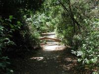
The start of the trail along Dorsett Road.
Starting off, the trail will consist of packed dirt, but most of the trail will be paved. A sewer or drainage line runs under much of the trail's length. Nothing in the line under the path emits any discernable odor though.

Soon after starting off we saw a common sight on this hike, a blown down tree across the trail. Since it had been weeks since Austin's last rain, much less storm, these roadblocks had been here for some time. One trunk was easily stradled and the second presented enough of an obstacle to previous visitors that a well worn path around the fallen tree had developed. We did see at least one fallen tree that had been cut up and moved to the side of the trail, so perhaps the maintainers are just behind schedule.

Several fallen trees presented obstacles along the trail.
At the waypoint "Tunnel 1" we reached the first of two trail under passes. The tunnels can be a little scary, in no small part due to the grafitti that adorns the concrete walls around and inside of them. Just to be on the safe side we probably would not recommend individuals pass through here at or near dark. In our four trips through the tunnels on this day we only encountered one man walking his dog after we exited one of the tunnels.

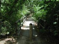
The bridges along the trail are safe, though one is missing some railing.
At the waypoint "Bridges" the trail will cross one bridge, turn right at the Y in the trail and then cross another bridge. One of the bridges offers another example of the neglect the trail is facing. Both bridges are fundamentally sound and very safe to cross. However, one of them has lost about half of its railing and vandalism seems more of a likely suspect than the age of the materials. After crossing the second bridge look for a continuation of the trail along the creek bed below.

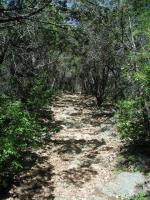
The hilly terrain along portions of the trail make for interesting scenery.
After passing through a the second tunnel at the waypoint "Tunnel 2" the trail condition and the scenary of the land around it improves. Nearby, you can take a break from hiking by searching for the "Demise of a Dot Com" geocache, which lies close to the trail. This is an easy geocache to find and thus makes for a good first effort.

The terrain along the trail gets more rocky, though the trail itself remains quite easy. Near the waypoint "Bypass" we came across an interesting looking waterfall with one crucial ingredient missing - water. Being in the middle of a drought certainly did not help our chances of seeing the waterfall at work and from the lay of the rocks this waterfall is probably most picturesque during or after a heavy rain.

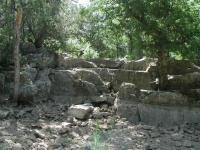
This waterfall probably looks wonderful with lots of water.
The bypass waypoint name is for the detour we took to avoid walking in stagnent water. The high rock face to the left discharges a small amount of water that gathers in puddles all along the trail here. To avoid this spot we simply stepped into the bone-dry creek bed and proceeded downstream for a short distance until the trail was dry again.

The trail actually did not end at the waypoint "Turnaround" where we headed back. However, the trail becomes very narrow at this point and poison ivy is prevalent, so continuing further in the summer is not advised.

By far, the most difficult portion of the hike was travelling up the rocky slope to the park.
We headed back with the intention of taking a side trail that leads into the heart of Balcones Park. The waypoint "Stairs" marks the spot at which the side trail breaks off from the main trail and heads straight up hill. This section of our hike helps push the difficulty rating up beyond the very easy level. The stairs are very rocky with lots of loose pebbles to make footing slighty difficult. The slope of the stairs provides a pretty good StairMaster-like workout.

When we got to the top of the stairs we found ourselves in an open field with picnic table and volleyball court without the sign of a single person. We continued towards the waypoint "Park", which involved crossing a small, but steep creek bed. Here a large playscape marked a more heavily used section of the park.

Our own private park at the top of the stairs.
There is the possibility that an alternate route back to the main trail could be found from this point. But we missed the opportunity to photograph the waterfall earlier, so we doubled back down the stairs and then onto the main trail and retraced our path back to the trailhead.

Our total trip time was about 2 hours and we covered 3.8 miles. Obviously the length and difficulty of the hike can be tailored by cutting out certain portions of the trail. This was an enjoyable hike but would be even more so with some maintenance on the trail.

Photos
spring
no matter how dry things are, the spring still flows (Photo by jimmy peace)
the springs
i actually sipped the water from here (Photo by jimmy peace)
after a heavy rain
loved the waterfalls (Photo by jimmy peace)
one of the springs
a spring on the trail (Photo by jimmy peace)
Nice artwork
Kids decorating the area? (Photo by Eveline)
Balcones Park trail
Ginger and Crumpet by the water fall. (Photo by Ginger)
After a good rain is the right time for this trail. (Photo by Caledonia)
Log Entries
lots of traffic
By jimmy peace on 8/18/2019
Rating: 1point5stars Difficulty: 1point5stars Solitude: 2point5stars
Distance: 6.00 Miles Duration: 4 hours, 30 minutes

creek was dry, always see nice folks  i walked it from balcones to walnut creek and back 

awesome
By jimmy peace on 6/10/2016
Rating: 3point5stars Difficulty: 2point5stars Solitude: 4stars
Distance: 4.00 Miles Duration: N/A

today i finally conquered the entire park... and even hiked from here over to walnut creek park, for a round trip total of 5.7 miles,. and even sipped from the springs

hiked right after the rains today
By jimmy peace on 5/19/2016
Rating: 3point5stars Difficulty: 1point5stars Solitude: 4stars
Distance: 1.80 Miles Duration: N/A

i didnt know this was the headwaters of walnut creek

Great wooded area
By Eveline on 5/18/2013
Rating: 2point5stars Difficulty: 2stars Solitude: 3point5stars
Distance: 2.00 Miles Duration: N/A

Enjoyed this hike.

No flowing water and stinky
By terlanmat68 on 9/9/2012
Rating: 2stars Difficulty: 1point5stars Solitude: 2stars
Distance: 3.00 Miles Duration: 1 hour, 8 minutes
This is a pretty interesting trail and would be even better had there been any water. In the lower area, the sewer smell was really bad.
By cwlatapie on 5/20/2012
Rating: 1star Difficulty: 1point5stars Solitude: 2point5stars
Distance: 5.00 Miles Duration: N/A

Some construction going on. The hiking trails had some trash and dog doo. Over all OK, I probably wont go back.

Enjoyed it quite a bit
By actualattic on 3/3/2012
Rating: 3point5stars Difficulty: 1point5stars Solitude: 2point5stars
Distance: 4.00 Miles Duration: N/A
Lots of birds. Was swooped by a hawk. Not a whole lot of people for a weekend. Parked at the park and went on the trail behind the pool. The trail was very rocky till you get to the main trail. The tunnels were neat.
Smelly but interesting
By elpea on 3/13/2010
Rating: 2stars Difficulty: 2stars Solitude: 3stars
Distance: 1.00 Mile Duration: 40 minutes

I started out my hike at the park and don't know what distance I covered.  As another user mentioned, there is a small trail behind the pool (two trails actually) that can take you to the main trail.   Maybe it's just because it's been rainy this year, but it was STINKY.  I was trying not to gag at certain parts. 

If you start at the park or want to go to the park, you have to go under two MoPac lane bridges side-by side.  Under one was a pretty elaborate homeless encampment, which is fine, but maybe not always safe for people going solo depending on the type of campers.  There's also a cool wooden train bridge. 

I wouldn't recommend going this time of year (winter/spring) if you don't want to get your feet wet because you have to cross some water at low points.  I turned around at the deeper water crossing, so I didn't make it to the end of the trail.

There were some interesting things.  On one side-trail, I found what looked to be a homemade BMX ramp course still in the process of being built out of dirt.  There's also lots of fallen trees and little bits of trash all along the trail.


By texaskdog on 3/12/2010
Rating: 3stars Difficulty: 2stars Solitude: 2stars
Distance: 3.00 Miles Duration: 1 hour

Nice path.  I would have given it a 4 as it is very nice except for 3 things: Its kinda short, the 2 tunnels are not lighted (you can see the light at the end but if there were somethign in the path youd trip and you cant take a bike through it, and you cant really get up to the street) and way too close to apts.

Beaten path OFF the beaten path
By Ginger on 11/22/2009
Rating: 3stars Difficulty: 2stars Solitude: 4stars
Distance: 3.50 Miles Duration: N/A

This is an interesting trail that runs between neighborhoods.  It is mostly paved, so it was perfect for a hike the day after rain showers.  Of course, that posed some problems where the trail was under water because the creek had risen.  The dog loved it!  4 dew claw up.  There were no people around so we let him off leash and he had a blast--wallowing in mud pits and splashing around in the creek.  The tunnels were a little creepy, but not too intimidating.  The water was high, so the water fall was very pretty. 

Only showing last 10 log entries. View All Log Entries

Recommended Item
Recommended Item 60 Hikes Within 60 Miles: San Antonio and Austin: Including the Hill Country
Charlie Llewellin, Johnny Molloy
List Price: $18.95 Your price: $15.91 Buy Now
It's Time to Take a Hike in San Antonio!

The San Antonio and Austin areas are steeped in history -- San Antonio's Alamo stands as a symbol of Texas' fierce independence, while Austin is recognized as the cradle of Texas statehood. This area is also known for some of the most impressive hiking in the Lone Star State. 60 Hikes Within 60 Miles: San Antonio and Austin, by veteran authors Charlie Llewellin and Johnny Molloy, guides readers to the best trails found in the Texas Hill Country, all within easy reach of these two cities. The guide takes you to secluded, low traffic areas as well as those that are more popular and heavily used. The former LBJ Ranch, the Guadalupe River, the Highland Lakes Chain, and the Lost Pines area are just some of the spectacular places covered.

With this new edition in the best-selling 60 Hikes Within 60 Miles series, all these visually stunning and ruggedly charming routes are at the traveler's fingertips. This handy guide helps San Antonio and Austin natives get back into nature, with many options right in town. Extensive at-a-glance information makes it easy to choose the perfect hike based on length, difficulty, scenery, or on a specific factor such as hikes good for families, runners, or birding. Each trail profile includes maps, directions, driving times, nearby attractions, and other pertinent details.