Getting there: McKinney Roughs is located right on Hwy. 71 between
Austin and Bastrop. From Austin, head east on Hwy. 71 past Austin Bergstom International
Airport. Proceed for about 10-15 miles and look for the park's distinctive rock wall
entrance with windmill on the left. For this hike however, you want to continue back
west along Hwy. 71 and take the next right on Pope Bend Road. Head north for about 3 miles
looking for the entrance to right. Please be VERY careful when leaving the parking area
after your hike. The visibility to the south at the intersection is very bad. Take a
moment and make sure that there is no oncoming traffic.
Note:
This hike is no longer open to the public. At some point the LCRA sold off the northern half of
McKinney Roughs to Hilton so that they could develop a resort on the property. The
southern half of McKinney Roughs is still open to
the public and now constitutes the entirety of the park.
The Hike: We call this hike the Northern Loop, but you won't find this
listed on the McKinney Roughs trail map. Instead, this is a loop that uses most of the
trails in the northern half of the park. It starts off at the waypoint marked "Trailhead".
Here you'll find parking and a port-a-potty. The northern parking area is always open,
which can be a big advantage if you show up on Sunday morning as we did. The main
entrance does not open until 1:00 PM on Sunday's.
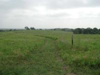
The start of the hike consists of rolling grassland. Note the trail markers which help guide the way.
The northern half of McKinney Roughs contains nothing but trails of mixed use hiking
and horse riding trails. This means that you will encounter horses on the trail and might
have to let them pass by you in close proximity. So you should be comfortable with that
before you start. When encountering horseback riders it's best to stop walking, step to
the side of the trail as much as possible and say a few words to the riders as they pass.
Horses get a little spooked when they encounter people like this and not making any
movements and speaking softly seems to help. It normally takes less than a minute for
them to reach a distance when you can resume your hike. Also, when hiking along this trail
it is always a good idea to keep an eye on the trail so that you can avoid the horse
manure!
-small.jpg)
As you get closer to the Colorado River the tree coverage increases.
The trail heads to the west and south. At first you'll experience rolling hills of
grassland. There are wildflowers here all around, though on May 20 most of the popular
wildflowers had already bloomed and gone to seed. Clumps of trees, including oaks, are
scattered along the terrain either on hilltops or along the paths of dry creek beds.
Perhaps up to half of the hike will be over terrain without direct tree coverage, so be
sure to bring along your sunscreen.
The topo map that accompanies this hike shows a variety of waypoints, most of which mark
the intersection of the trail with others that you might want to explore. For example,
the "Rim Trail 1" waypoint marks the point at which a trail forks off from the main trail
and heads east towards the waypoint "Rim Trail 2". In all McKinney Roughs has over 18 miles
of trails, so there's more than enough left to explore to keep you coming back.
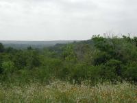
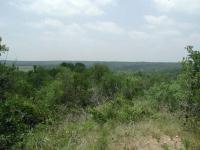
Looking down a valley towards the river. The next ridge over comes up later on the trail.
When the trail gets to the waypoint "Ranch Ridge" you will begin to notice a difference in
the terrain and foliage. While open areas can still be found you'll find more and more
trees as you get closer to the river. The Northern Loop is one of the more interesting
hikes for viewing different types of ecosystems in a short day hike.
When the trail gets to the waypoint marked "Coyote Road" turn right and head to the west.
The jeep trail that shows up on the topo map is the same route that the trail follows now.
Be on the lookout for signs along the trail that point to the scenic outlook marked on our
map by the waypoint "Scenic View 1". This short side loop provides a beautiful view of
the valley below looking towards the Colorado River.
After exiting the scenic outlook loop you find a metal shed just off the trail with its
roof on the verge of collapse. We suspect it was used during the park's days as a ranch
since it does not appear to have been used in years.
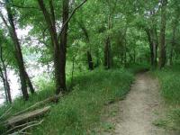
Sandy Trail along the Colorado River.
The trail continues along towards the west, working its way around the valley that we
overlooked at the scenic view. Upon reaching its end the trail turns south east along
McKinney Roughs' Road Runner trail. This section of the hike mostly follows a ridge along
the far side of the valley. When you get to the waypoint marked "Coyote Road 2" you'll
start to notice another difference. The trail will become less rocky, the soil
will occassionally be sandy. The type of trees along the trail will also change. Although
the oaks remain you'll see more Sycamores and Cottonwoods. During our visit the
Cottonwoods were demonstrating how they got their name as clumps of cottony material
could be found rolling along the trail.
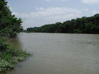
A clear view of the Colorado River. Note the island upstream.
The trail turns to the north east when it gets to the Colorado River. Along this stretch
there are several optional trails that proceed in the same direction as our choice though
further away from the river. You're best bet for getting right up to the river is at the
waypoint marked "Water". Mostly there is thick brush and trees separating the trail from
the river outside of that point.
The McKinney Roughs trail name for this portion of our hike is Deep Sandy. Much of this
stretch is not sandy, but occasionally you will run into very sandy patches. The
interesting thing about the sandy portions is that the texture of the sand is not like
what you might expect to see at a beach. Instead the sand is very finely grained, almost
like ashes.
Although hidden by all the trees, the Colorado River flows below.
Soon thereafter the trail turns away from the river. Soon after waypoint "Coyote Road 3"
be prepared for the climb up a steep slope to get up to ridge level. After hiking for
several miles and the heat coming down you might want to stop for a breather after getting
to the top.
Again, be on the lookout for a sign indicating a scenic overlook. We've marked the spot
with the waypoint "Scenic View 2". When you reach the waypoint "Coyote Road" once again
you've reached the home stretch. Proceed back up the same trail used on the trip down
to the waypoint "Ranch Ridge". In order to avoid trail duplication we chose a different
route to get back to the trailhead.
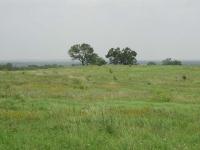
The trail back returns to the grasslands. To the left in the distance you can see the parking area.
McKinney Roughs' Ranch Ridge Trail is similar to the Grassland trail we used at the
start. There are rolling hills and small clumps of trees. Along this stretch you'll
come across a very large well that appears completely dry. It seemed an odd place for
a well since it was near the top of a hill, which would seem to indicate that drilling
down further into the rock would be required.
Near the waypoint "Rim Trail 2" the trail will cross a sometimes creek bed with somewhat
steep sides. After crossing that it's just one more hill to get back to the starting
point.
This hike was a lot of fun, though we suffered a bit from the heat even with the large
quantities of fluid we consumed. During the summer it is highly recommended that you
tackle this hike only if you get a very early start, or cut the hike a litle short
by turning back early. Our trip this day covered almost 5 miles with about 600 feet
of ascent.