Walnut Creek Park

Trail
2.00 Miles
380 Feet
N/A
3stars (3.27)42
1point5stars (1.98)
2stars (2.11)
N/A
Yes
Yes
No
Austin
Travis
More Info

Some parts of Walnut Creek Park are a maze of trails, which can be confusing at times.
The land for Walnut Creek Metropolitan Park was purchased by the city of Austin in 1964. Before it was a park, it was owned by the Gracy family as a part of their farm. In addition to hiking trails, there is a complex with three softball diamonds, basketball courts, a swimming pool that is open in the summer, and a very large open grass field that is sometimes used for cricket matches. There are lots of picnic tables and trash cans near the parking areas. An electrical substation adjoins the park, so there are three high power electrical tension lines that cross the park.
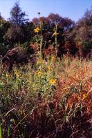
There are several meadows in the park, filled with wildflowers, tall grass and prickly pear cactus. (Photo courtesy of <A HREF='/My?UserName=kharker'>kharker</A>)
There are several meadows in the park, filled with wildflowers, tall grass and prickly pear cactus. (Photo courtesy of kharker)
There are more trails and side paths crossing the nooks and crannies of the park landscape than you will probably ever be able to explore. There are some larger paths that can make great loops. The route described here is just one of many options. The loop and the two side out-and-back trails is about two miles in total length, with a total vertical climb of 380 feet. The trail is either natural stone, light gravel, or dirt - there are no paved sections. There are four creek crossings. Depending on how the rains have been in the previous month, the crossings are either very easy to make without getting wet at all, or will require walking through ankle-deep water. The approaches to the creek crossings can be a little steep, and occasionally muddy. Give yourself at least two hours before dusk to complete this hike.
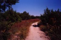
There are some large, double-track trails in the park that form a couple of big loops, popular with joggers and the less adventurous mountain bikers. (Photo courtesy of <A HREF='/My?UserName=kharker'>kharker</A>)
There are some large, double-track trails in the park that form a couple of big loops, popular with joggers and the less adventurous mountain bikers. (Photo courtesy of kharker)
Begin the hike by heading due south from the parking lot. There is signage at the trail head, explaining park hours. You will quickly reach a large wide path that runs northwest-southeast, along the ridge above the Tar Branch of Walnut Creek. Take a right, heading northwest. At the waypoint "Fork1", there is a fork in the trail, and our path take the right fork. After passing through dense trees (where we lost our GPS reception briefly) the trail passes near a chain-link fence and a park maintenance "Shed", off to the right. The trail takes a left here, and crosses the Tar Branch of Walnut Creek. Just pass the creek, there is a "Fork2", our second fork, where we took a right.

After passing through some woods, the trail emerges atop a small hill with a reasonable view of the neighborhood to the northwest of the park. The land on the north side of the park is open with many meadows and grassy spaces. At "Fork3", we take a left. (Another trail goes to the right and out of the park, connecting to the adjoining neighborhood.) The trail now follows the main Walnut Creek downstream. At "Drop", there is a steep side trail that forms a little loop with the main trail. It is very popular with mountain bikers. Follow the trail southeast until the "Side Trail" waypoint.
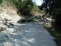
Several creeks and streams run through the park, sometimes cutting out steep rock banks.
The "Side Trail" waypoint marks an out-and-back portion of this trail. If you want to take a shorter hike, simply continue southeast on the main trail. From the "Side Trail" waypoint, take a right. This is a smaller trail that winds, at times steeply, down to the creek. At the creek, there is a flat, rocky sandbar. If you follow the sandbar all the way to the left, you can see a path on the opposite side of the creek. This is the trickiest creek crossing in the trail, so be careful.
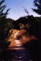
The trail, as it enters a small meadow. The evergreen trees on either side of the foreground are cedars. (Photo courtesy of <A HREF='/My?UserName=kharker'>kharker</A>)
The trail, as it enters a small meadow. The evergreen trees on either side of the foreground are cedars. (Photo courtesy of kharker)
On the opposite side of the creek, follow the trails that hug the tributary stream, which will be on your right. As you go uphill, following the GPS track, you will eventually reach "Waterfall", a small but quite pretty waterfall. You can turn back, and then head to the southeast. There is a hill overlooking the park here, and the trails going to the top can be somewhat steep. The hill is about 80 feet above the creek. Because of the steep trails, this is one of the more popular spots for mountain bikers. The GPS track for this portion of the out-and-back includes a side trip to the southeast on a small trail that became indistinct in the leaves and ground cover. There are many side trails in the park like this that can be fun to explore. The GPS track follows a trail that heads back to the previous creek crossing "Cross1".
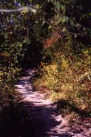
The trail goes through both open spaces and very densely overgrown spaces. (Photo courtesy of <A HREF='/My?UserName=kharker'>kharker</A>)
The trail goes through both open spaces and very densely overgrown spaces. (Photo courtesy of kharker)
Once you've reached the main trail on the north side of Walnut Creek, follow the trail, taking a left to head away from the creek. This takes you through alternating woods and meadows until you approach a 4-way intersection. Take a right to continue southeast down to the creek again. "Cross2" is a creek crossing that is not as difficult as "Cross1". Once you cross the creek, take a right to continue going southeast. Near the southern boundary of the park, you will cross the creek one last time at "Cross3". The trail on the opposite shore is steep as it climbs up from the creek. Once you reach the top of the incline, there is a fork, "Fork5", which we took to the left. This trail is one of the larger, flatter, and more heavily travelled trails in the park. if you take the trail to the right, it will follow the Wells Branch of Walnut Creek, terminating at the entrance road near the Lamar Street entrance. Our GPS track takes a left, going north and then northwest along the ridge above the Tar Branch of Walnut Creek, and back to the parking lot.

There are any other trails and destinations in Walnut Creek Metropolitan Park. This two mile loop doesn't cross or go near the Wells Branch of Walnut Creek, which flows on the east side of the park.

Photos
muscadine grapes
the wild muscadine grapes were yummy (Photo by jimmy peace)
pyrite
one can find pyrite nuggets along the creek (Photo by jimmy peace)
big boulders
some of the big boulders along the creek (Photo by jimmy peace)
Walnut Creek
A shot of the park's namesake. (Photo by estudio64)
creek
Just a quick pic of the creek. (Photo by nocman)
Log Entries
watch out for the mountain bikers
By jimmy peace on 7/25/2017
Rating: 3stars Difficulty: 2stars Solitude: 2stars
Distance: 3.20 Miles Duration: N/A

one can also get easily off main trail, cause of all the well traveled bike trails

By Jamie on 6/1/2017
Rating: 3stars Difficulty: 1star Solitude: halfstar
Distance: 2.00 Miles Duration: N/A
lots of traffic
By jimmy peace on 3/21/2016
Rating: 3stars Difficulty: 1point5stars Solitude: 1point5stars
Distance: 2.50 Miles Duration: N/A
By jimmy peace on 2/2/2015
Rating: 3stars Difficulty: 3stars Solitude: 3stars
Distance: 2.70 Miles Duration: N/A
Great Park
By cwlatapie on 2/28/2013
Rating: 3stars Difficulty: 1point5stars Solitude: 1star
Distance: 5.00 Miles Duration: 4 hours
Great Park there are a lot of people dogs and bicycles. The park needs a little help staying clean. If we could just pick one thing up every time we visit. I believe that will solve most of the problems. Great place. I'll keep going back
Decent hike with lots of trails (lots of the same trails)
By bowlesfamily on 8/21/2012
Rating: 2stars Difficulty: 2point5stars Solitude: 1star
Distance: 2.00 Miles Duration: 1 hour, 15 minutes
NOTE: comments only refer to the small section of Walnut Creek that we traversed. We hiked this with a six year old and a medium-sized dog on a Tuesday afternoon. The trailhead is located in the middle of the Walnut Creek Metropolitan park, so it is in a fairly busy area to start off with. On the positive side: there are many, many different small trails running throughout Walnut Creek, with excellent signage and a trail map posted at strategic positions throughout the park. On the negative side: the trails are a bit on the repetitive side and very easy (this could easily be a positive); also, we experienced a garbage-like smell in various areas. Overall, we would say that Walnut Creek is a good choice for people who want quantity, since there are supposed to be 17 miles of trails wound up within Walnut Creek proper.
A Relaxing Escape - Even on Easter Sunday
By estudio64 on 4/8/2012
Rating: 4stars Difficulty: 2stars Solitude: 2stars
Distance: 2.50 Miles Duration: 2 hours
It was Easter when we took this ramble - with no real preparation other than knowing where the park was. The developed part of the park was overrun when we got there - not necessarily a bad thing - families out enjoying the day with games and barbeque. It wasn't long until the din of veneration was at our backs and out of sight. The off-leash aspect of many of the trails was a hit with Zoey, who enjoyed venturing into the brush and galavanting in the water. Easter 2012 in Austin was a pastoral spring day, making the hike all the more enjoyable. The power lines in the park are unsightly and, at times, unhinge the illusion of a natural getaway, but that is my only criticism of Walnut Creek Park. Definitely worth it, power lines and all.
Dogs especially loved the creek!
By stephdorf on 6/10/2010
Rating: 3stars Difficulty: 1star Solitude: 3stars
Distance: 2.00 Miles Duration: 40 minutes

I can't believe I lived a mile from this hike for 5 years and never even knew it was there! We had a great time even though it was shorter than we would have wanted. There seem to be some side trails that you can take to extend the length but we didn't know about them until later.  Dogs can go off leash here so I wouldn't recommend this hike if you have a dog phobia. Our dogs LOVED the creek area and the water was so pretty that I very nearly jumped in too.  We came here the day after a hard rain and the trail was super muddy to the point were the bikers had to walk much of the way. Also..my shoes were thick with mud by the time we were done. Overall it was a great time and I would definitely recommend this hike .

Wrecked my bike; had a great time!
By ryan6351 on 3/10/2010
Rating: 4stars Difficulty: 4stars Solitude: 2stars
Distance: 5.00 Miles Duration: N/A
The first time riding Walnut Creek, I tried to take it a little slow. The trails were pretty narrow, and most were either up or down hills. It was a really fun ride, until I came across a rough hill. Going down, I lost control and hit a tree. However I easily found my wait out, using signs on the trail, and am definitely going back again!
Best hike in Austin
By texaskdog on 3/4/2010
Rating: 5stars Difficulty: 3stars Solitude: 4stars
Distance: 4.00 Miles Duration: 1 hour

17 miles of trails, yet if you stay in the front half never more than 5 minutes from your car.  Many creeks & water crossing, lots of trees, back part is very isolated.  I've been there a couple dozen times and never been on the same hike twice.  No good map to speak of but you can find one online, but it is great just to wander.  You could spend hours here and never get bored.

Only showing last 10 log entries. View All Log Entries

Recommended Item
Recommended Item Austin (Lone Star Guide to Austin)
Richard Zelade
Your price: $15.95 Buy Now
Lonely Planet Pocket Austin is your passport to the most relevant, up-to-date advice on what to see and skip, and what hidden discoveries await you. Jump into the icy waters of Barton Springs Pool for instant relief when the heat gets too much, catch a local band at the Continental Club or one of the hundreds of live-music venues around town, or watch the nightly exodus of America's largest urban bat colony during summer, under the Congress Avenue Bridge; at all with your trusted travel companion. Get to the heart of the best of Austin and begin your journey now!